The tide affects the water level during the day, more or less according to area navigation. The most of time in one day there are two high tides and two low tides, period between to tides is around six hours roughly. The tide period shifts approximately fifty minutes per day(see “ tide”)and evolves like a sinusoid curve. The difference of water level between high tide and low tide, called tidal range changes over the month in intensity(see “ tide”), this change is characterized by the tidal coefficient.
1)The tidal coefficient
This is the first number to copy before making a calculation of tide, without unity it evolves between 20 and 120. The lower it is the more it indicates a little tidal range and weak currents; the higher it is the more it tells us about a strong tidal range, so strong currents. This number is shown in tidal almanachs, or other books on the tides during a year. It is also used to calculate the strength of the currents. Under coefficient 70 it is heavy water( low tidal range)and above 70 we are in spring tide(rather strong).
2)Evolution between tides
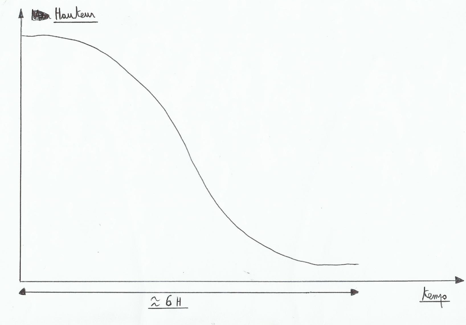
As we can see, tide does not change as a straight line. At the beginning it's falling slowly, accelerates quickly in the middle and ends slowly . We therefore realize that when there will be more water circulation, when there will be more current it will be mid-tide, or three hours before or three hours after a low or high sea level. Times when there will be less current will be close to slack(during high or low tide). The easiest way to find the height of water which is available at a time and a given location is to draw a graph, but problem: as we have seen before, tide does not change linearly, and draw freehand a sinusoidal curve is not very accurate!
3)To right a sinusoidal curve
This method makes us lose a bit of precision but it is simple. As noted above the time between low and high(or vice versa)is around 6 hours, it is the tide time and it is found simply by calculating the time between them(example, 6 hours 24 minutes). A tide hour, it is tidal time divided by six 6(So here 1 hour 4 minutes).
We accept the tidal evolution in that way; first we divide the tidal range by twelve 12. The first tide hour, there will be an increase or decrease of 1/12 of the tidal range, the second tide hour 2/12 th, and the third tide hour 3/12 th(where currents are the strongest). The fourth hour still 3/12 th, and after that the pace slows down at the fifth hour 2/12 th and finaly at the sixth tide hour 1/12 th. This is the rule of twelfths.
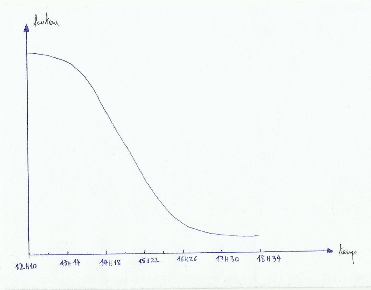
In this graph, abscissas provides tide hours. A tide time is here an hour and four minutes, at the end if you have done it right you'll find the slack time hour. This is marvellous but we are still bothered by our curve to draw! to draw a line instead of a curve we will change abscissas and in a same time we will keep in our mind the twefths rule:
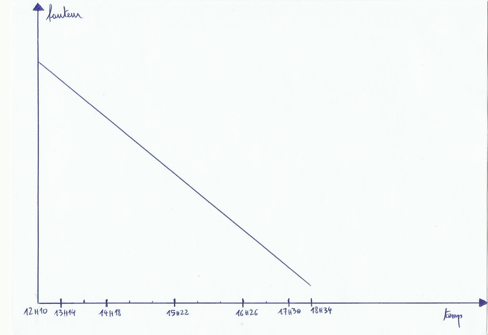
The second tide hour will take twice as big as the first, the third tide hour twice as big as the first tide hour…we have a graphic that instantly gives us the height of tide in a given area.
Only add this tide height to the depth indicated on the map to see the depth encountered at this time. Written depths on charts are those when the sea is at its lowest level(low tide coefficient 120). On green areas(foreshore, places covered or uncovered by the tide, drying heights)or on some points of the map there are numbers highlighted. To find the depth here we substract highlighted number to our tidal height. if the number is negative, it indicates the emerged height of the rock or something else at this place. Small example:
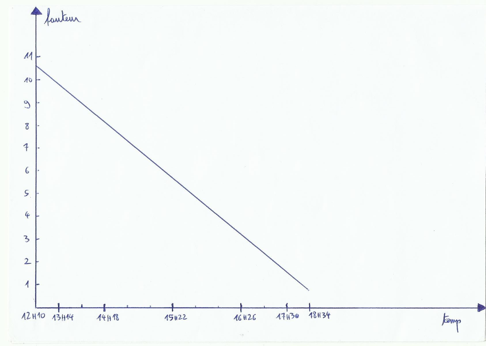
On the chart we notice a depth of 1 meter at a channel's entry, calculating tide above is about our navigation's area. Our boat has a draught of two meters. We keep a safety margin(under keel clearance)of one meter. We want to know if at 15 hours 20 there will be enough water to pass. According to the graph 15 h 20 we have 5 meters 70 for the tidal height, so in the channel's entrance we will actually have 6 meters 70 of depth at 15 h 20. Under the keel at this place there will be 4 meters 70 of space, well above the 1 meter of under keel clearance, it's cool you can go on without unpleasant surprise.
4)Corrections
In tidal's almaniachs there are reference ports, for example if you want to know the evolution of the water level at Brest, just take Brest timetables to draw your graph. However for Loctudy datas, you must first take the timetables and the tidal heights of its reference port which is Port-Tudy. height and time corrections change depending on whether you are in spring or neap tide; to be as accurate as possible it is better to use tidal neap corrections when the tidal coefficient is between 20 and 45, and spring tide corrections when the coefficient is between 95 and 120. Between 45 and 95, we work out the corrections average.
Always check the reference time data, if all data are in UT and one hour, Don't forget to add an hour in summer(usually from March to October).
5)Other things to consider
The atmospheric pressure affects the water level too. Average atmospheric pressure number is 1013 hpa(on the sea surface) 1013 hpa, for each hpa above this average number we subtract 1 cm(atmosphere pressure push water), and for each hpa under this number we add 1 cm.
The wind also affects the average sea level by its action. An sea wind(grown on the sea)will increase the average level(for a strong wind roughly 50 cm)and wind from the coast(offshore wind)will usually lower the level(50 cm less in strong winds). It is difficult to precisely quantify the change in height depending on the intensity of the wind. It explains in part why by strong gust of wind from the sea during high tide with high coefficient, there are overflowings in some ports.
Wind can also change the duration of ebb and flow, mid-tide time doesn't change. For example offshore wind decreases flow's duration and obviously increases ebb duration, and it's the contrary for sea wind.
Areas next to a river exit can undergo tide timetables modifications whether rain has poured recently, the rising tide just can be delayed.
6)Under keel clearance
I think the best is to take 1 meter to be quiet. However, when the sea is rough with large waves heights, you must increase according to wave height. For example if we meet two-meter waves, we increase the keel clearance by adding two meters.
Good day, Just happen to dropped by your site. I’m so interested on how the ‘Tidal Coefficient’ Table was formulated or calculated. I there any specific link or additional articles that could shed info on this subject.
Hoping for a Favorable Response.
Sincerely,
Marben
In fact currently in spite of my lack of time i’m seeking about things talking about that subject too, because i’m trying to do a little software able to use moon positions to calculate navigation positions (like with the sun and the stars), and if i would manage to do that, with my program based on the sun normaly it would be possible to add up some lines to calculate tides coefficient in the same way. For the moment i have only found data on wikipépé on the page “marée”in french, which explains how coefficent is calculated with a little formula, and how sun and moon positions creates tides forces on earth, but honestly for me the link between their positions, the tides force done and the coefficient brought back at the end is still blurring, especially between the forces and the coefficient. I have found a french book written by alexandre Moatti which is called ‘les indispensables astronomiques et astrophysiques pour tous”; inside there is a chapter usefull because it describes tides and forces, syzigy and quadrature but it is not focused on about how those forces work on the tidal coefficient range. If i would find something more interesting i will send you the link.
Regards